Flood Risk and Planning Procedure - Weaknesses in the System
There are two main weaknesses in the planning process for new development. The first is specifically related to flood risk and the "Flood Maps for Planning" provided by the Government. These flood maps, which are accepted by local authority planner, are used by developers to determine whether a site is at risk of flooding. However, they are only flood maps for fluvial or river flooding which is an error because there are other sources of serious flood risk including surface water and overland flows of water.
The National Planning Policy Framework (NPPF) states in a footnote to Para 163 that ‘other sources' of flooding should be considered. However, this is in practice, completely ignored by the planning process which only focuses on fluvial (river) flooding. Further, the classification of land into three Zones, 1, 2 & 3 of Flood Risk (least to most) also only relates to fluvial flooding. Planning policy needs to be significantly strengthened to insist that all sources of flood risk are fully considered in the developers’ site specific flood risk assessments and if necessary, hydraulic modelling be provided for all sources of flood risk and not just fluvial/river flood risk. Without a change of policy, new homes will continue to be built on land that is deemed free of ‘fluvial’ flood risk but at risk of flooding from other sources.
The second weakness in the planning process is this. Site specific flood risk assessments are provided by developers in their applications for planning permissions are prepared by independent consultants who act for the developers. As described in the para above these flood risk assessments only focus on fluvial or river flood risk. These documents include many disclaimers categorically stating that only the consultants’ clients (ie the developers) may professionally rely upon these documents. These are the legal contracts between the consultants and their clients, the developers. The consultants’ professional liabilities are not extended to any third parties, meaning if the consultants' reports contain mistakes or are misleading, no third parties that suffer losses because of these mistakes have recourse to the courts for compensation. However, local authority planning departments, who are very much third parties, rely entirely on these consultants’ reports to determine whether (in the case of flood risk) proposed development sites are safe to develop and suitable for granting of permissions. This is in clear breach of the consultants’ conditions and hence there is a legal weakness in the planning system.
The independent consultants who are engaged by developers to prepare reports on matters such as flood risk are bound by industry codes of conduct and are required to carry professional indemnity insurances in case they make mistakes. However, it is only their clients that can make legal claims for losses and not third parties as the legal contract is between the developers and the consultants. It follows that those that suffer losses, such as flood damage or worse (fires from burning cladding?) have no chance of compensation as it is a complete non starter for individuals, often with limited means, to turn to the law and try for compensation as their legal pathways will be blocked by the consultant-client legal contracts.
It therefore appears the entire planning process is a self-regulating honesty system and at its heart are the commercial relationships between the developers and the the consultants. It is these consultants who prepare safety critical evidence to ensure there is no objection to the granting of planning approval by the local authorities.
To ensure better checks and balances, transparency and accountability, the local authorities who grant planning approvals should insist the consultants’ professional liabilities are extended to them, without restriction, thus allowing the planning departments to fully rely on the reports and if necessary resort to the law to seek compensation from the consultants in the event of mistakes made by them. Unlike most private individuals, local authorities do have the means to engage legal help. Without this extension of liabilities, the local authorities, should not rely on the ‘self certified’ developers’ submissions at the planning stage.
Most consultants are independent, upstanding, unbiased and honest and depend upon these sound principles for their commercial activities. It will therefore be of no difficulty for them to extend their liabilities to local authority planners if the law were to be changed. For those consultants that may not by so honest or unbiased, a change in the law could help them mend their ways!
It would just take a simple change in the law governing planning policy.
Back to flood maps to back up the first weakness described above.
Parts of Lower Brailes are at risk of flooding from both fluvial (river), surface and overland-flow sources. The gov.uk website provides flood maps for information at this link https://flood-map-for-planning.service.gov.uk
Lower Brailes has suffered from recent flood events in 2019, 2016, 2012, 2007 and 1998. Many many historic flood events are recorded elsewhere.
This is the flood map for fluvial (river) flood risk in Lower Brailes. This represents the extent of flooding from Sutton Brook, however, local knowledge points to Hen Brook and Scuttle Brook also being sources of fluvial flood risk. The flood risks are categorised as High, Medium and Low. These mean the following risks: 1 in 30 chance of annual flooding, 1 in 100 chance of annual flooding and 1 in 1000 chance of annual flooding respectively. This is the flood map used for planning.
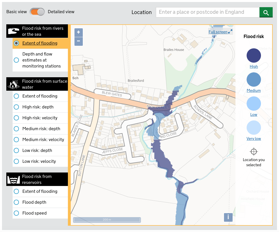
Flood Map used for Planning. This is only for fluvial (river) flood risk.
Surface water flood risk is a known to be a major contributor to flood events generally and this is the case in Lower Brailes. This is exacerbated by overland flows of water arriving at the convergence of Sutton and Hen Brooks. The surrounding catchment is largely clay and therefore infiltration is limited. The overland flow of water also arrives from the north of the B4035 beside Castle Hill Lane and this passes directly over the main road, overwhelming the road’s drainage system, before going overland to Hen Brook. As before, the extent and depths of the surface water flood risk for Lower Brailes are provided by the gov.uk flood maps and at three risk levels; high, medium and low. These are the same annual risk factors described above. These surface water flood maps are not generally considered for planning purposes. Photographs of the recent flood events in Lower Brailes are recorded on this web site which may help the reader to compare the flood maps with the evidence.

High Risk Surface Flood Map, Lower Brailes. 1 in 30 chance of annual flooding
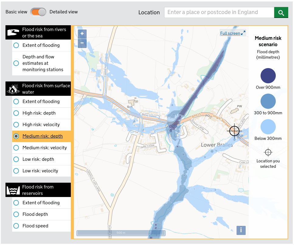
Medium Risk Surface Flood Map, Lower Brailes. 1 in 100 chance of annual flooding
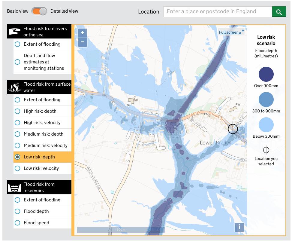
Low Risk Surface Flood Map, Lower Brailes. 1 in 1000 chance of annual flooding
Feb 2020
